Friday, July 14, 2017

Day 55 - Sight Seeing St. John's

Today was our last day of sight seeing in St.John's and we started it by walking down to the harbour. We saw a number of new ships since the last time we were there, namely two battleships and a really nice super yacht.


Her Majesty's Canadian Ship (HMCS) St. John's

Le Dumont D'Urville (French Navy)

Super yacht Archimedes 
Have have a look at this site Marine Traffic Global that shows all of the ships in and around Newfoundland. Click on a ship symbol to get detailed information.
Another big off shore supply ship, the Atlantic Heron

Looking out towards South Head in St. John's harbour, we spotted another iceberg. Impossible to tell how big it is. Referred to as a "growler" by the Islanders.


 A "growler" iceberg
After coffee and chocolate, we headed off to "The Rooms". We made it up one last time to King Street, to view "Jellybean Row Houses". The painter that was working there on Tuesday was still there and another just starting on a side street.

The Rooms is an archive, an art gallery and a museum that occupies four floors of a most incredible space. We spent almost three hours there and could have easily spent two days. To facilitate your visit, they give you a "10 Must see - Highlights" list". We spent quite a bit of time in the World War I exhibit, specifically the Battle of Beaumont-Hamel. This battle litterally changed the course of history for Newfoundland.  


From The Rooms looking out over St. John's harbour

The incredible space that is The Rooms

The blue house on the corner was recently purchased as a
summer home by an Newfoundlander returning home

This row of well kept homes dates back to 1892. Notice how steep
the road to the right is

This has to be the longest pedestrian cross-walk we have
ever seen. 
On one of our tours, the guide posed the following question: "In paradise, how can you tell who the Newfoundlanders are? Answer: "They are the ones who want to go home!" After almost three weeks in Newfoundland, we can relate to that desire that they have to go home. We want to come back as well!

Tomorrow we fly back to Ottawa.

This is the last of our daily blog updates. In two weeks (or so) look for another blog entry that will address "Lessons Learned from the trip". We enjoyed sharing our trip with all of you and very much appreciated your comments and other such feedbacks.


See you in two weeks

Hélène et Daniel

Thursday, July 13, 2017

Day 54 - Touring Bell Island


Today we had planned to take a tour of Bell Island. We found out about Bell Island from a retired school teacher in Stephenville, who was born on there. We knew about the submarine iron ore mine and of the sinking of four ore ships by a German submarine during WW II. Two really good reasons for a visit. 

Our guide, Darrin Steele, from Newfoundland TOURS.com picked us up promptly at nine o'clock and we were off to pick up more tourists before heading to Portugal Cove to catch the ferry. We discovered this morning that although there is a ferry schedule, the schedule is extremely flexible and can change on a moments notice. The island is serviced by two ferries that carry 33 vehicles each that are to be replaced by one 66 vehicle ferry. The new ferry is currently in service at Fogo Island until they get their own new ferry. The docking facilities here at Portugal Cove and at Bell Island are currently being upgraded to handle the bigger ferry. 

The cliffs of Bell Island


Nearing the Bell Island ferry dock.


Our multi talented dancer, singer, musician and tour-guide, Darrin Steele

On the drive to the island, Darrin captivated us with his in-depth knowledge and contagious enthusiasm about all things Newfoundland. We could have listened to him all day. After a brief stop at Harry's lookout, we were off to the #2 Mine Museum. At the museum, we were met by Teresita McCarthy who is good friends of John Basha (Stephenville) who told us about Bell Island.


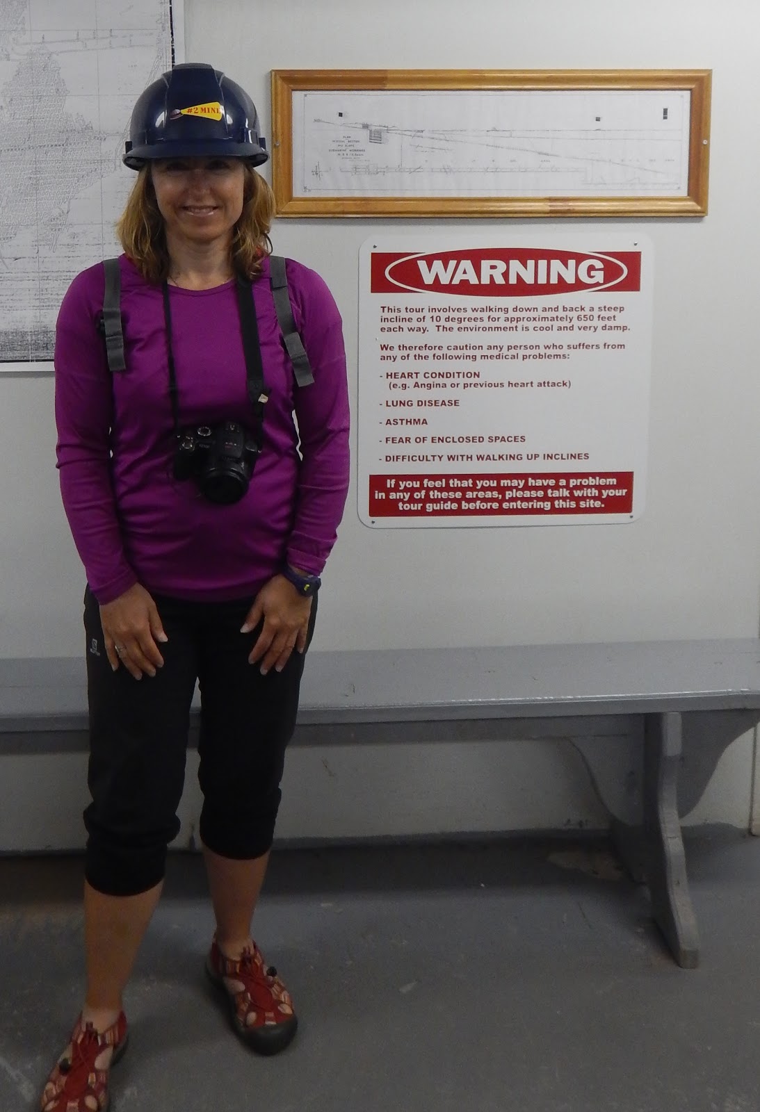
Helene ready to head down into #2 Mine, to a depth of 100+ feet


Looking back at the entrance to the mine, we walked down a 10%
grade for about 650 feet

The horses and Newfoundland ponies stalls. The animals
worked a month on and were taken above ground to rest for a
month before doing it all over again

Water inside the mine limits the depth that the tour can go.
There are scuba diving tours of the mine

The mine operated from 1895 to 1966. At the time of its closure, Bell Island was Canada's longest continually operating mining project. The work week consisted of 10 hour days six days a week, with only the Sunday off. Before the use of machinery, all work was done by done by hand. The work was physically demanding and dangerous. Once the iron ore was removed from the rock face, it had to be shoveled by hand into a trolley by a team of two miners. Your day was done when you had filled 20 trolleys. When the mines were running all out, the population of the island was around 13,000 now it is around 2,700 people living in the Town of Wabana, Lance Cove and Freshwater. 

The boss would mark out where the holes had to be drilled, the holes were drilled and dynamite inserted and the rock face blasted. A scraper would use a metal bar to remove remaining loose rock and the ore on the ground would be shoveled by hand. Blasting would be done when the folks using shovels were off shift.


(From L to R) Picker, driller and shoveler

Our guide turned off the lights to give us an idea of how dark it is in a mine. We could not see our hands. To find out more about iron ore mining have a read of this CLEVELAND IRONSTONEMINING. It is about mining in the UK but I think it must be similar to how it was done in #2 Mine.

Bell Island is one of the few locations in North America that German forces directly attacked during the Second World War. German submarines sunk four ships.


Yousef Karsh was hired by the mining company to take pictures


Bell Island light house. It used to be near we were standing for the
 picture. It was moved due to erosion. 


Something to consider for our next visit to Newfoundland, a small
gas motor on our bicycles.


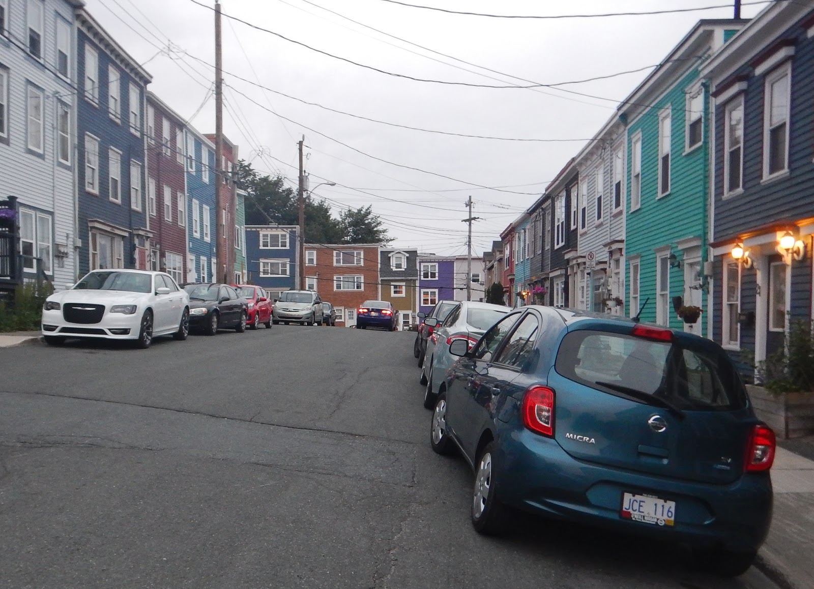
Monk Lane, even steeper than the street we photographed a few
days ago. Look at all those steps


Front display window at Jenkins & Puddicombe Sheet Metal Ltd

On our way back from Bell Island, we were dropped off at the grocery store where we did a little shopping for some local food stuff. We bought some of the ingredients needed to make Fisherman's Brewis when we get home. 


(From L to R) Jam Jam, Salt Fish and Hard Bread 

We had planned to pedal to Bell Island but after the tour we took on Tuesday, we decided that we would get more out of an organised tour and we were not disappointed. 


Tomorrow are doing a self guided walking tour of downtown St. John's and have a number of places we want to visit.

Wednesday, July 12, 2017

Day 53 - Mount Pearl to St. John's Harbour, Newfoundland

14.1 km - Total so far 3,368.90 km


RWGPS: https://ridewithgps.com/trips/16010075
Relive: https://www.relive.cc/view/g12853724496

Today we pedaled to the site in St. John's Harbour, Newfoundland where Terry Fox dipped his artificial leg in the ocean and began his journey. We thought it would be a most fitting place to end our own Eastward to "The Rock!" adventure.


"I just wish people would realize that anything is possible if you try; dreams are made if people try"  Terry Fox


8.76 miles - Total so far 2,093.33 miles

Tuesday, July 11, 2017

Day 52 - Mount Pearl (Sight seeing around St. John's)

0.00 km - Total so far 3,354.80 km


We had looked forward to cycling to Cape Spear but I was not comfortable going there on our bikes. Yesterday, we had two incidents when drivers told us to "Get off the &*%$# road" and this was on roads where the posted speed limits were 40 kph on one road and 50 kph on the other. It is a narrow road with no shoulder to speak of going to Cape Spear. With Cape Spear being a major tourist attraction, I would expect there be quite a bit of traffic and not all of it made up of relaxed drivers thrilled at the sight of two heavily loaded touring cyclists sharing the road with them. 

This is definitely not the outcome we had envisioned since leaving Port-aux-Basques more than two weeks ago.

Today we took a day off from cycling and played tourists in St. John's. After a nice lunch of moose burgers at the Shamrock City Pub, we got on the Legends Tour mini-bus for an afternoon of sight seeing. 


First stop on our tour Cape Spear

Picture of a flower taken at Cape Spear


The well rested cyclists masquerading as tourists

The quint village of Quidi Vidi 

St. John's North and the harbour taken from Signal Hill

Yours truly on the deck of the Cabot Tower, Signal Hill

Two people walking on the trail at Signal Hill and a white thing
in the left corner

Cabot Tower as seen from St. John's Harbour
After the mini-bus tour we wandered off on our own first along the waterfront. There are many large ships and lots of information panels that cover different aspects of the life and times of the City of St. John's. We then went back to look at the Jellybean Row Houses. At the Tourist Information we were directed to three streets but once you start, you find out that there are more than three streets with those homes. With each new house you must find a more interesting and colourful one. 
The Maerske Cutter. Off shore resupply ship that doubles as an
 iceberg tug as required

Jellybean Row Houses on King Street


More Jellybean Row Houses on Prescott Street

Even more Jellybean Row Houses

Holloway Street is so steep that there are steps and handrails on the side walk 

Prospect Street note how much higher the left side of the street is.
You must need your arm and leg to open the driver side door on the lower side of the street.

We had loads of fun walking around the neighbourhood very near St. John's harbour. Tomorrow we will pedal to the Terry Fox Monument and bring to a close our "Eastward to "The Rock" bicycle trip. Unlike Victoria, there is no "Mile Zero" marker in St. John's but we felt that the Monument that marks Terry Fox's Mile Zero would be a most appropriate place to stop.

0.0 miles - Total so far 2,084.57 miles

Monday, July 10, 2017

Day 51 - Brigus to Mount Pearl

70.50 km - Total so far 3,354.80 km


RWGPS: https://ridewithgps.com/trips/15962901
Relive: https://www.relive.cc/view/g12809695551

I don't know if you picked up from reading yesterday's blog that we really liked Brigus. Upon leaving the campground, we spent another 45 minutes touring Brigus and snapping pictures. Once on the road, our destination was Mount Pearl.


John's house (campground owner) and small bridge over the brook

Post office and community hall. Note the white picket fences

A good portion of Brigus is built on hillsides, more white picket fences 

The hill goes up quite a ways. Again white picket fences

St George's Heritage Church (big white building with black
and reddish roof)

We once again we followed the Old Conception Bay Highway, so we rode through one small community after the other. The highway runs from Cupids all the way to St. John's along Conception Bay.

In Conception Harbour, we spotted a number of boats at the wharf. There Helene started a chat with an older gentleman who was working on an old building. He identified himself as the owner and a resident of Philadelphia who was up here on holidays with his son from California. His father is a Newfoundlander and he inherited the property. There is a long standing relationship between Newfoundland and the United States and this is evidenced by the number of US flags we have seen flying during our ride through the island.

Three sizes of fishing boats in Conception Harbour. The two
 smaller boats are made of wood

Conception Bay as seen from Avondale

Conception Bay as seen from Harbour Main

A big tractor with not two but three tandem wheel axles 

No nice brook picture today so North Arm River picture in lieu

Conception Bay as seen from Holyrood

 Monument of Honour, Conception Bay South

Bell Island as seen from Topsail
Once again, we made use of a multiuse trail to get around a built up area (city). As we neared Mount Pearl, we got on the Newfoundland T'Railway Provincial Park. We discovered from talking to that cyclist from Belgium that near St, John's the trail was covered in stone dust and usable by bicycles. We had observed the trail before but then, it was only suitable for 4x4 all terrain vehicles. The trail got us quickly to our motel in Mount Pearl.

Newfoundland T'Railway Provincial Park, Mount Pearl

It was a nice ride today along the Old Conception Bay Highway. It took us through many small towns and we learned quite a bit about Newfoundland history. Now we are in a suburb of St. John's and getting around on loaded touring bikes will not be nearly as relaxing. We will make use of the T'Railway Park whenever possible.

43.81 miles - Total so far 2,084.57 miles