Friday, June 30, 2017

Day 41 - Deer Lake to Sheppardville

99.00 km - Total so far 2,678.90 km


RWGPS: https://ridewithgps.com/trips/15696089
Relive: https://www.relive.cc/view/g12600968693


The Fab Four: France, Daniel, Hélène and Felix at the campground
 in Deer Lake
Mother Nature was kind to us this morning in that there was no spectacular scenery to stare at. This enabled us to focus our gaze on the side (shoulder) of the road and find treasures, and a treasure we did find. I spotted the multi-tool in the image below and this is the best find of the trip so far. At approximately 31.87 kilometres, the scenery improved significantly.  


Multi-tool found on the Trans Canada Highway

Outbound Multi-tool showing attachments

Sandy Lake in the distance (kilometre 31.87)
This part of Newfoundland should be called "The Lake District" as there is one lake after the other very near the Trans Canada Highway. In order, we came across Sandy Lake, Birchy Lake and Sheffield Lake.
Follow the ridge from the left. An unusual rock sitting atop
the mountain. It looked like a human brain (to us)

Just trees and bugs we were told! Birchy Lake and mountains
that are getting bigger
On the stretch of road pictured above, the sun was out, we had the wind in the face and believe it or not, it rained pretty hard for about 3 kilometres. There is rarely a dull moment here in Newfoundland.


The road shoulder can be soft at times and a challenge to cyclists.
The tool is 3 1/2 inches long

Those of you that have looked at our proposed route in Newfoundland, the route included a stop at Gros Morne Park. After meeting with and talking to locals and other visitors to Newfoundland, we determined that a return trip to Newfoundland is necessary. Instead of a side trip off the Trans Canada Highway (TCH) we will visit places that are on our route and close to the TCH, in the area around Conception Bay. Our next trip to the Rock will be in our VW Bus and will include North and Western Newfoundland.

61.52 miles - Total so far 1,665.15 miles

Thursday, June 29, 2017

Day 40 - Corner Brook to Deer Lake

61.10 km - Total so far 2,580.80 km 


RWGPS:https://ridewithgps.com/trips/15676955
Relive: https://www.relive.cc/view/g12582745667

We stayed in a commercial area of Corner Brook last evening and we did not get to see much. First thing this morning, we headed downhill towards the downtown. We saw some nice neighborhoods with very well kept homes. At City Hall, there was an impressive little cenotaph and we absolutely had to stop. From across the street, a kind lady offered to take our picture.


Statue of an Afghanistan veteran (on the left) and a Bren Gunner
from the  First World War. The statues commemorate the sacrifices made by Western Newfoundland soldiers
We left town pedaling along the waterfront on Riverside drive. Nice and flat and no hills! 

Bay of Islands, from the wharf in Corner Brook


The "Newfie Bullet
On advice from a resident walking along Riverside Drive, we stopped for breakfast where else but at "Breakfast Mountain". The name comes from people stopping for a rest and breakfast before heading up the Humber River. If you look at the picture below, in the middle you can see what appears to be the picture of an old man etched into the mountain.

Old Man in the Mountain


Breakfast at Breakfast Mountain. The start of the Humber Valley can
be seen behind me.


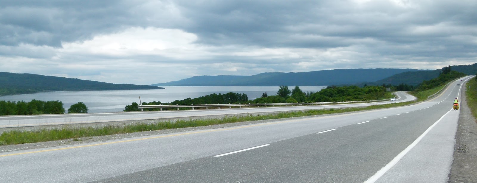
The Humber Valley. Cliffs on either side of the road and spectacular scenery
We had a terrific ride through the Humber Valley. Nice rolling terrain and a few hills made it possible to make time to take pictures and to relax and enjoy ourselves. It was also an opportunity to stop and chat with Brian, a cyclist from Niagara Falls, who we had seen a few times before and waved at. This time we took the time for a chat. Brian will be seeing a lot more of Canada this year than what we have planned. We wish him safe travels.

The best roadside find on this trip. This safety flag will be recycled
into flags for our bicycles for our next trip.

Deer Lake seen from the Trans Canada Highway

Deer Lake as seen from our campground

Hydroelectric station in Deer Lake built in 1922. It put Deer Lake
 on the map
Today we stopped for lunch at Pizza Delight and took advantage of the all you can eat buffet. We don't think they made money with us this time. There we were approached by a lady customer who so kindly offered us a place to stay for the night.With thanks we declined her offer as we had a campsite lined up. She came back later and told us that she had contacted her husband and he was prepared to pick us up in his truck. She gave us her name and phone number and told us that if we had any issues on the remainder of our trip to contact her for help. I would think that is without a doubt a manifestation of Newfoundland hospitality. At her request, we will not list her by name. Once again thank you so very much!

We had another chance encounter at the campground. Helene and I belong to the Biking Across Canada Facebook group. On that group, Helene became friends with Felix, from Germany who was also travelling to Newfoundland about the same time as us. Who did we run into at the campground but Felix.


Helene with Felix at the campground
All in all we had another great day in Newfoundland. Made new friends, met new friends and enjoy Newfoundland hospitality at its best. What else could we ask for!
37.97 miles - Total so far 1,603.63 miles

Wednesday, June 28, 2017

Day 39 - Stephenville to Corner Brook

84.0 km - Total so far 2,519.70 km  


RWGPS: https://ridewithgps.com/trips/15653810
Relive: https://www.relive.cc/view/g12561831958

We had a good night sleep boondocking just off the golf course in Stephenville. We were far enough away that we were not bothered by the sprinklers. We decided not to make breakfast but to swing by McDonald's, have breakfast and take advantage of the facilities.

We left Stephenville along Route 460 that took us to the Trans Canada Highway (TCH). Route 460 is a quiet country road that took us through a valley of wetlands and on which, we got to see our first live moose on the island. Once we hit the TCH, there was not nearly as much scenery as yesterday so we just got into pedaling towards Corner Brook.


The wetlands off Route 460. It is a small valley with mountains on
either sides.

Hélène had the camera out but it took for ever to focus. You can see
the back end of the moose (in line with the truck)

The first road sign listing "St John's"

We spotted another cyclist stopped by the side of the road, looking at the back of his bike. I went across the road to see if everything was okay. The cyclist was Belgian and I tried having a chat with him in French but he informed me that he did not understand my French. We tried English. I found out he just had his bike repaired in Corner Brook and that he was on his way to Niagara Falls. Once I got back to my side of the road, Hélène commented that he did not have a whole lot of equipment with him for someone who is crossing Newfoundland. 

At kilometre 720 (from St-John's),  there is a really nice lake 

What a great place to put an add for MacDonald's next to a
magnificent lake
 
On the road, we were honked and waved at by a couple of ladies from Québec who we keep running into since we first saw them in Sydney North, Cape Breton. Also at lunch, we ran into another cyclist that we first encountered on Day 11 and again on Day 36.

Parts of the City of Corner Brook with the Bays of Island in the back

Corner Brook has a population of around 20,000 and from our taxi driver, we learned it is hell to drive in in the winter. The whole place appears to be built on the side of hills and mountains. British captain James Cook was the first to survey and record the geography of the Bay of Islands.


52.20 miles - Total so far 1,565.67 miles

Tuesday, June 27, 2017

Day 38 - Robinsons to Stephenville

65.00 km - Total so far 2,435.70 km 


RWGPS: https://ridewithgps.com/trips/15635056
Relive: https://www.relive.cc/view/g12544079794

We decided to make it a two day trip from Robinsons to Corner Brook. Destination for today is Stephenville, some distance  off the Trans Canada Highway but a nice change of pace. We took lots of pictures as once again we had lots to stare at in ha! 

We had intended to make it to a campground some seven km outside of Stephenville but we noticed campers on the waterfront. We inquired with some folks at McDonald's and they confirmed to us that you can camp there without any issues. The hardest thing will be to pound our tent pegs in, given that the campsite is at the end of an old US Air Force runway. The US Air Force operated Ernest Harmon Air Force Base in Stephenville from 1941 until 1966. Many Air Force buildings are still standing and are being used by the community.

We also learned while at McDonald's that we absolutely had to visit Bell Island, off the northern coast of Newfoundland. We got this from a gentleman who was born there. Another reason to come back to Newfoundland and have us a much longer visit.  


A popular fishing spot off the Trans Canada Highway. We are
sworn to secrecy as too the exact location 

Brand new towers for power lines. Might have something to
 do with Muskrat Falls hydro project

"Nothing but trees and mosquitoes as you ride across
Newfoundland!"  Who ever came up with that description has
 never  turned a pedal on Newfoundland soil

My first roadside find, a fairly new rubber bungee tie-down.
 It even has the tag on it 
If you ever wondered what it is like to cycle across Newfoundland, well it is like going over a gigantic washboard, covered with uneven ridges. Some ridges are small and others are much bigger. 
Follow the road and you can see the washboard, up and down
and up and down and  more up!

The wetlands near Stephenville Crossings

Wind blown trees with the perpetual bad hair day. All the trees
lean to the right away from vertical. 

This was one big ridge on the washboard. Worked up an
appetite on that one

Helene just coming over the top of the ridge. I got to pass her
as she stopped to take my picture above.


The plaque reads "F-102 Delta Dagger - Presented to the Town
of Stephenville by the United States Air Force to commemorate Ernest
Harmon Air Force Base and the friendship established with its personnel
 July 21st, 1990"
The first Newfoundland fishing boats we have seen

Hélène and the bicycles taking a pause

Hélène made supper right on the beach at St George's Bay

Golf bunker Newfoundland style

Home for the night - boondocking with some of the RVers


40.39 miles - Total so far 1,513.47 miles

Monday, June 26, 2017

Day 37 - Doyles to Robinsons

69.90 km - Total so far 2,370.70 km


RWGPS: https://ridewithgps.com/trips/15606653
Relive: https://www.relive.cc/view/g12519272669

Today was one of those days when the distance to be covered was dictated by accommodations. The campground at Barachois Provincial Park was deemed to be too far for us, so we looked for other places to stop. We found a motel near Robinsons. 
Want to advertise your septic tank business, paint faces on them

Once we left the Codroy Valley, the views were not as spectacular but we did find some unusual things by the side of the road. Once in a while, we stopped for pictures of rivers as they are much easier to frame in a picture than a valley.


Hélène is handy at many things but throwing is not one of them.
She was aiming for the ditch with that banana peel


Another hill climb. The climbs are not steep but they are long

One of the many trout fishing rivers we came across while on the Trans Canada Highway. 
In many of our pictures, you can see the Trans Canada Highway, You can see a smooth surfaced road with wide shoulders, making it easy for all types of traffic to move on. We were somewhat surprised when we came across a sign announcing "Rough road for 10 kilometres". Boy they were not kidding. The surface of the road was so damaged, that at times, it was easier for us to ride on the worn rumble strip on the shoulder. It was a good thing that there was no scenery to look for those 10 kilometres as your focus was on avoiding the holes in the asphalt. 

The "Long Range Mountains" in the background

Another trout fishing Newfoundland River. 

The two of us in a small dory with our bicycles
We are spending the night at the Mid-Way Motel (it is midway between Port-aux-Basques and Corner Brook). 


43.43 miles - Total so far 1,473.08 miles

Sunday, June 25, 2017

Day 36 - North Sydney (NS) to Doyles (NL)

41.10 km - Total so far 2,300.80 km 


RWGPS: https://ridewithgps.com/trips/15587284
Relive:  https://www.relive.cc/view/g12501749267

We pedaled our bikes to the ferry at about 10:30pm. This ferry is the biggest one we have taken so far. Unlike other other ferries, we boarded  near the end behind a lot of the big trucks and campers. Once we had 'dumped' the bikes, we made our way to Deck 9 and our reserved seats.

On Deck 9, we met Adnan, a young businessman from Toronto who was taking advantage of business meetings to visit Gros Morne National Park. We trust that he will have a great time. We then tried too and finally went to sleep during the 8 hour crossing. We slept as best we could and got up at 6 a.m. to have breakfast.


Hélène getting ready to hit Newfoundland cycling 

MV Highlanders was named to recognise the service of Highland
Regiments in Nova Scotia and Cape Breton

Yesterday we mentioned that part of the plan was to surprise the Tourist Information in Port-aux-Basques. We were the one's that were surprised. This has to be the best prepared tourist information that we have ever seen in our travels across Canada. They had answers to all of our questions, they had hand drawn maps and the mileage they quoted turned out to be bang on. We were told groceries were 6 kilometers away from our intended campground. Turned out to be bang on. The weather was horrible when we got to Port-aux-Basques. We were told don't worry, it will be sunny by the time we got 15 kilometres away. Again they were right.


Welcome...you would never think so given the fog and rain.

About 15 kilometres from Port-aux-Basques, full sun and a bit of snow

Warning of high winds. We wondered what locals consider 'high winds to be"


Not what we normally see when shown pictures of Newfoundland. Absolutely stunning scenery

The Codroy Valley. Picture taken on our way back from grocery shopping 
Once at the campground, we had to go grocery shopping. We had been told that Gillis Brothers Auto Parts and Grocery Store was 6 kilometres away form our campground and it was. What we were not told is how scenic the Codroy Valley was. That made our 15 kilometres shopping trip so much more enjoyable. The Relive below gives you an idea of what we cycled for groceries and a few beers.


We had a nice stay at the campground and got to run into another cyclist that Hélène first met in Rivière-du-Loup. She had come to Newfounland a day before us and experienced the major rainstorm that Environment Canada had forecasted and that caused us to purposely delay our coming to Newfoundland by one day. 


25.54 miles - Total so far 1,429.65 miles